
Owens Farm Detailed Information Page
As promised in our e-mail of 16th January, this document provides further details of the Owens Farm planning application and topics to consider for your own objections
We cover:
- What is proposed and concerns in general
- How the application will be assessed
- Implications of it being an outline planning application
- More detailed reasons to object
- Further activities
- Conclusion with details of how to object
What is Proposed & general concerns
Outline planning application Ref:25/02564/OUT for up to 415 dwellings, landscaping, open space, SANG, SuDS, and associated works with access from Newnham Road (principle and access to be considered) at Owens Farm Newnham Road Hook RG27 9NG has been submitted. The extent of the development is shown below.
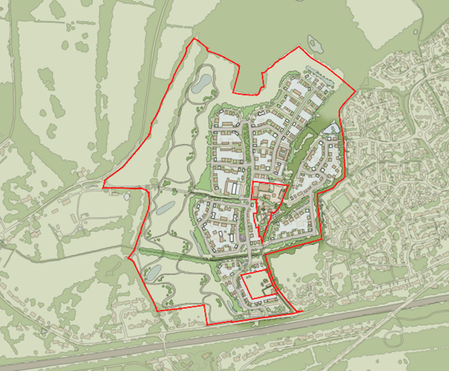
A development of this scale raises serious concerns about traffic and highway safety, pressure on schools and already overloaded GP services, drainage and flooding, loss of greenfield land, and conflict with the Hart Local Plan and Hook Neighbourhood Plan, which supports only sustainable, proportionate development that respects the village’s character and infrastructure limits. The proposed access is from Newnham Road, a road with limited pavement, poor visibility and barely wide enough for two cars to pass.
The illustrations above show that if this greenfield site application is granted then it will be very difficult to stop a further application for approximately 50 houses in the field at the end of Hop Garden, such approval would further accentuate the issues identified above.
The applicant undertook a ‘virtual’ Community Consultation last October we were surprised to see it included the following.
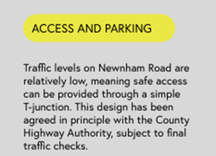
We have followed this up with Hampshire County Council Highways Authority. On 12th January we received the following statement from Hampshire County Council Highways Authority
“I can confirm that we haven’t agreed anything with the applicant in terms of the access design for this application.”
The claim is repeated in the application. Need we say more?
How the Application will be assessed:
The first paragraph of the National Planning Policy Framework, NPPF states:
“The National Planning Policy Framework sets out the Government’s planning policies for England and how these should be applied. It provides a framework within which locally prepared plans can provide for housing and other development in a sustainable manner. Preparing and maintaining up-to-date plans should be seen as a priority in meeting this objective.”
Paragraph 8 states “Achieving sustainable development means that the planning system has three overarching objectives” which it then identifies as economic, social and environmental and describes them
Paragraph 9 states “These objectives should be delivered through the preparation and implementation of plans and the application of the policies in this Framework”
The NPPF very clearly requires development to be undertaken in a planned way. Hart has a Local Plan and Hook a Neighbourhood Plan both validated by the Government until 2032. They identify sites to achieve the Government target of building 423 new homes a year. The Government has subsequently changed that target to 750 per year without giving Hart time to plan where to locate them. This makes the plans out of date.
Where plans are out of date then planning applications can only be refused when the adverse impacts of approval would significantly and demonstrably outweigh the benefits. Failure to meet a plan policy is no longer considered grounds for refusal even if that specific policy is still considered valid despite the plan being out of date. It is considered a disadvantage which, with all other disadvantages, is compared against the benefits to determine the application.
Therefore, it is essential that we identify as many disadvantages as possible and provide facts and reasons for considering them as a disadvantage.
Outline Applications
The application is for outline planning permission. Outline planning permission allows for a decision on the general principles of how a site can be developed and is granted subject to conditions requiring the subsequent approval of one or more ‘reserved matters’.
The application document Owens Farm Planning Statement states in the following paragraphs
4.2. “Only the principle of developing the Site for the proposed land uses, including up to 415 dwellings (C3 use), including 40% affordable housing (166 dwellings), and a SANG, together with the means of access from the junction of Newnham Road are to be determined as part of this outline application”.
4.3. “Other aspects of access, as well as appearance, landscaping, layout and scale are reserved for subsequent determination.”
It subsequently identifies two plans which it states, “comprise the Application plans for approval” and nine plans which it states are “are submitted for illustrative purposes only but provide context for the council’s assessment of the potential impact of the scheme upon the site and the character of the area”. It does not clarify the purpose and standing of the other 91 documents in the proposal if the application is approved. This must be clarified because if the application is approved based on the descriptions in the 102 documents then these descriptions must be enforceable in the development.
Risk associated with this ‘outline’ process:
The NPPF is not clear on how reserved matters should be determined when there is not an up-to-date local plan. With an up-to-date local plan, the reserve matters must fully meet the plans policies. Unless this approach is adopted for reserved matters with out-of-date plans there is a risk that the reserved matters may introduce further disadvantages which would have caused the outline application to be refused.
Imposing conditions on any approval of the outline application may reduce this risk. However, they must be incredibly stringent to completely remove the risk. Hence this application is premature. The applicant should either wait until Hart Local Plan is updated or submit a full application to remove the risks identified
Reasons to object – detail to support the summary table published in our email
General comments
Such a development will generate an extra 1000 journeys per day on Newnham Road. These will cause major problems on narrow Newnham Road, its junction with Old School Road, the bend in Old School Road by the railway bridge and at the proposed T junction providing access to and from the site. The SANG itself will attract further traffic.
Surrounding narrow roads are not adequate to cope with the considerable amount of construction traffic necessary to build such a large development. The resulting traffic problems will increase throughout the construction phase as built properties are progressively occupied.
The applicant proposes changes to alleviate these problems for motorists, cyclists and pedestrians. However, those changes are inadequate and, in some cases, simply not deliverable. Let’s dig into the problems a little more deeply following the reasons in our table
Is the location sustainable or not?
For the proposed development to be acceptable in principle, it must be in a sustainable location and not in conflict with adopted policies – and one of those adopted policies is the local Gap
The Local Gap
The site is a greenfield site outside the current Local Plan defined settlement area and in the Hook / Newnham local gap.
The Neighbourhood Plan designates the area between the settlement boundary of Hook to its western edge and the boundary of Newnham at its eastern edge as the Local Gap and this gap is vital to maintain to avoid physical and visual coalescence of Hook and Newnham – thereby protecting their individual characters. The developer claims there will still be A gap and, whilst this may be the case, it is not THE gap which is prescribed by the Neighbourhood Plan. Accordingly, the location fails the test of building in the gap and causing coalescence between the villages.
And then Accessibility
The site needs to be close enough to local amenities so that it can be accessed by sustainable modes of transport – principally walking and cycling – and not be reliant on car use. The walking and cycling routes need to be safe for all users including disabled users and children’s buggies. The entrance to the proposed site at its southeastern edge is 1km from the centre of Hook increasing to 1.3km from the centre of the site. The railway station is a further 200m with the nearest supermarket at Tesco 100m beyond. Hook infant and junior school is approximately 1.7km distant. Whatever the reality may be of people being prepared to walk a 3.4km round trip twice per day to drop off and pick up children from the school or a 3.2km shopping trip, the walking routes must meet minimum standards and the developer’s improvements to walking along Newnham Road do not meet these standards:
Safe Access?
Does it provide safe access for motorists and pedestrians and cyclists? And is that access deliverable?
- Even if the land required to form the new footway to the north of Newnham Road was within the highway boundary, as the developer claims, building a 2m footway would cause the road to narrow in stretches to considerably less than the 5.5m claimed and building a narrower footway to increase the road width would be both inconvenient and dangerous for pedestrians.
- Even using the developer’s own figures, of the 220 additional vehicle movements in and out of the proposed development in the peak AM hour, 30% would use Newnham Road heading to/from Hook. Adding 66 cars in an hour to what is currently, and will continue to be, a narrow road will cause congestion and increase the risk of both vehicle and pedestrian accidents
- The proposed footway would be across land not within the highway boundary of several houses
- Cyclists using Newnham Road will have to navigate 2 narrow pinch-points, with increased traffic on an already busy, narrow and dangerous Newnham Road. Motorists do NOT observe the speed limits and simply endanger cyclists as well as pedestrians
Flooding and sewerage
Hook’s infrastructure is struggling without these 415 extra houses and many will remember the relatively recent queues of tankers taking away sewage. Surface water flooding has occurred in Newnham Road and without adequate preventative measures this will accentuate these problems
Ecology
More on this coming soon….
Building in the Gap – see above under Sustainability
Schools/nurseries and Doctors
School places simply aren’t available. Hook infant & junior as well as Robert Mays are full. If local school places can’t be found, then pupils will have to travel further afield – stress on them and MORE car journeys inevitable – adding to the unsustainability concern. Even if they can expand schools with measures such as portacabins in the playground such enlargement may well have a detrimental effect on the children’s education. The need to provide transport to Robert Mays School for every secondary age child on the proposed development does not reflect the sustainability required by the NPPF
Similarly for nursery places. Many parents already have to drive considerable distances away from Hook to find a nursery place and more houses will make this worse.
Everyone reading this will not need too much commentary about trying to secure appointments with a doctor/medical professional. 1000 additional residents???
Visual Landscape impact and impact on surrounds
Whilst the developer claims that the site will have limited impact on the views into the site, their survey was conducted when the hedges and trees were in full leaf rather than winter when the lack of leaf, bloom means the site would be visually prominent in the landscape for many months of the year causing loss of amenity protected by both the Local and Neighbourhood plans
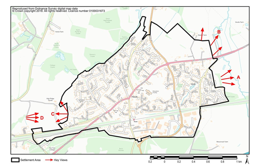
The development would harm the character, visual amenity and scenic quality of the landscape by urbanising a countryside location with the proposed houses. The figure below identifies key viewpoints from Hook that are defined in the Hook Neighbourhood Plan. The proposed development would destroy the views from C and considerably denigrate those from D (in the next diagram)
And let’s be honest, provision of the SANG will further urbanise the area being more urban park than open countryside.
Church Path & Heritage
Public Right of Way PRoW 25b (footpath) from the end of Hop Garden to Newnham known as ‘Church Path’ will be seriously degraded by this urbanisation. It has both historic, and amenity value and is included in Hampshire County Council’s Historic Environment Record. It is extensively used for exercise and enjoyment of the countryside. The degradation will result in considerably fewer people using it and benefitting from its health and pleasure attributes.
The development would also degrade the setting of the historic farmhouse and granary visible from the PRoW/footpath at Owen’s Farm. These are listed as Locally Significant Heritage assets in the Hook Neighbourhood Plan
Further Activities
Assessment of the application continues …..
We are reviewing the application and to date have extracted the information to help you with your thoughts and subjects prior to your own objection. We will continue to review it. However, the application contains 102 documents with lengths up to 99 pages. Much of it we will only be able to skim read before the deadline for objections. Any assistance will be greatly appreciated.
Owing to the number of documents, many without clear titles, it is difficult to know where to start. A good place is the Owens Farm Planning Statement which is the last document in the Document List on the Hart Planning portal for this Owens Farm application
Specifically, Section 4 Description of Application Scheme and Section 5 Summary of Supporting Application Particulars. Not only do these describe the scheme they also on a topic-by-topic basis describe the scheme’s “advantages”. If you are sceptical or have a particular interest on any one topic and would be prepared to review its supporting detailed documents to determine whether the claims are realistic, we would be most grateful. Please advise us if you are willing to do so we can ensure that there is not duplication of effort.
Let us know via email: hookdevaction@gmail.com
Publicity
We have leaflets being delivered in next few days and posters going-up around the village. Be assured any materials in public spaces will be removed promptly after deadline date. The Basingstoke Gazette has reported on the application (20th January 2026) in their on-line edition.
Conclusion
We urge you to object to this application considering the shortcomings identified above and threat to quality of life in all of Hook.
Sections 2 and 3 above identify shortcomings in the planning system and the fact that it is premature which should not allow it to be approved. Section 4 identifies the many specific disadvantages of the application. We need to identify as many disadvantages as possible to counter the “benefits”.
Please advise friends and neighbours of this application and urge them to object.
Everybody in a household can object and need not be a resident of Hook or even Hart. We would suggest that you do not object jointly to ensure that every individual objection is counted.
We would also ask that you try to put your objection in your own words and not cut and paste from here. There is no need to go into all the detail that we’ve included, it has been included to help you understand the significant issues if this application is approved
Remember that important date Friday 6th February
It is essential that we get as many objections as possible to stop this application.
Thank you in advance for your assistance and patience getting this far.