
Update on Brown Croft, land at High Ridge Farm
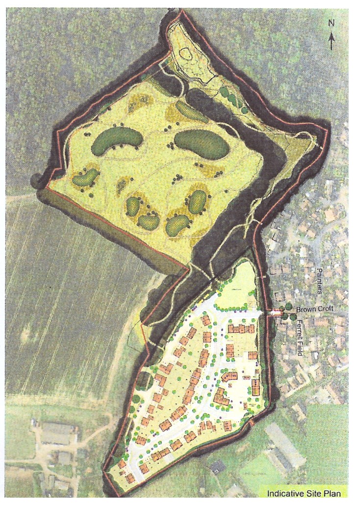
Persimmon has submitted yet another planning application Ref: 22/01506/FUL to erect 65 dwellings and a SANG in the field at the end of Brown Croft.
This site has a very long planning history.
In summary, in 2013 Taylor Wimpey submitted Ref: 13/02567/MAJOR for 60 dwellings and a SANG. This was approved.
It was disappointing that this development was granted permission, but at that time, Hart’s Local Plan was not yet approved, so developers were able to benefit from that lack of local control. The site then had to be designated in the eventual Hart Local Plan for future development with 60 dwellings.
It transpired that Taylor Wimpey were unable to proceed with the development because it did not have access rights to the site from Brown Croft. Eventually the access issues were resolved between Taylor Wimpey and Persimmon and Persimmon then proceeded with various pre-application discussions with HDC.
This site is now a designated site in the Local Plan, and as such, Hart will probably approve any appropriate planning application.
So, what next? And how can you help?
While the principle of development on this site is not in doubt given that it is in the Local Plan and the site had prior planning approval, that doesn’t mean a sub-standard development will be or should be approved and we ask you to object to this current application.
Main reasons to object
TRAFFIC
- Brown Croft road is described by the developer as a ‘low traffic cul-de-sac’ whereas we know it’s a busy road proving access to 5 other roads (Lay Field, Shaw Pightle, Scures Road, Painters Pightle & Ferrell Field). In all, approx. 70 properties use Browncroft currently. This isn’t ‘low traffic’ AND with the proposed 65 new properties this would result in 95% increase in traffic + additional traffic to make use of the new SANG (see below).
ISSUES WITH THE HOUSING DEVELOPMENT
- 65 properties have been planned, leading to a cramped and overdeveloped site
- Prior approval was for 60 properties, the extra 5 now proposed are not needed per the Local plan/housing supply
- Inadequate parking/car-spaces for the housing proposed
- Documentation has many inconsistencies – for example:
- Footpaths are shown at 2m or 3m in different documents – which is it? If 2m in some areas, these aren’t suitable for pedestrians & cyclists
- Traffic movement plan doesn’t agree with Access plan
- With such inconsistencies in the planning application how can we be sure what is expected to be delivered? The details submitted must be made to be consistent.
- Affordable homes are concentrated in one area and not distributed throughout the site per planning policies
- Comments in Design and Access statement bear no relation to the site itself
- No amenity space provided
SANG – Privately owned – 5.4 hectares
- This will be an additional traffic generator using Browncroft
- There would be 5 unallocated parking spaces for SANG but these would also be expected to be used as overspill for residents – this is inadequate.
- The size of this SANG is enough for 3 x the houses proposed. So it might appear this developer is expecting more development in the area and being able to sell SANG to others and therefore resulting in even more traffic
- Boardwalk height (2 feet) near Sheldons Path likely to cause overlooking/privacy issues to residents
- This ‘formal’ SANG completely destroys the natural field/countryside that is there currently.
- Wildlife and birds will lose natural habitat not only due to the changed environment but also the introduction of cats and dogs to the area.
OTHER ISSUES
- Limited infiltration/drainage. With climate change issues we all face, any development needs to be providing high standard handling of water/flood risks. We know issues already exist within this area in terms of attenuation tanks and boggy fields and water run-off from current Brown Croft area.
- Community engagement promoted, but developer has done very little consultation in our opinion and not consulted HPC (as committed to in the pre-app)
- Site plans show an egress from the new development to an adjacent field – indicating more developer led proposals perhaps? This should not be permitted.
To know more about the application, please look at the “Design and Access Statement” and the “Planning Statement”. These give an overview of the proposed development including road and cycle/footpath layouts, the green spaces to be provided and the style and heights of the houses proposed.
These documents can be found on the Hart website at:
https://publicaccess.hart.gov.uk/online-applications/applicationDetails.do?activeTab=documents&keyVal=REV17WHZ0NC00
There are over 150 documents related to this application: the 2 we’ve recommended are titled on the website as:
- HOOK DAS FV
- HOOK PLANNING STATEMENT DRAFT FV
To comment on this application, you can do so through the above link. The closing date for comments is Wednesday 31 August 2022. All comments will be taken into consideration by Hart and your time and effort will be worthwhile helping this potential new development bring high quality living space to our village.